Linea P map
See the map
 Bunker
 German
 Civil war
 Not verified or destroyed
The project
The Línea P map is a project whose objective is to identify the bunkers built from 1936 in the Pyrenees. From 2015 to 2022, the map was a collaborative project where anyone could add the bunkers they discovered!Click on a bunker on the map to see its photos.
What is the use of the Línea P map?
To organize themed hikes in the Pyrenees
These unusual bunkers can become the goal of walks or mountain circuits! They can motivate children (and older ones) on the theme of a treasure hunt or an observation game...
To promote urban exploration tourism (urbex)
By promoting these unusual monuments, Línea P map makes it possible to create a new tourist activity (bunkerology) in all the territories of the Pyrenees.
To preserve the memory of Pyrenean history
By listing all the bunkers, this map elevates the entire system to the rank of a monument and allows us to understand what these concrete blocks camouflaged in the middle of the mountains are. It highlights this magnificent heritage of military architecture (humans are generally inspired when it comes to beating on it).
To understand the overall strategy of the system
The map, comments and photos will allow to fully understand the layout plan decided by the Spanish strategists.

The Línea P
The P Line, sometimes called the Pyrenees Defense Organization or the Gutierrez Line, is a set of defensive bunkers (military fortifications resistant to enemy fire) built in secret under the regime of dictator Francisco Franco. It was mainly intended to prevent the Allies from entering Spain. Using the 500 km natural barrier formed by the Pyrenees, it has an impressive number of bunkers: the map currently counts 3,249 bunkers of Línea P, including 2,296 verified and 953 very likely. The highest bunker is 2,507 m above sea level (GPS 42.43958, 1.56357).It is made up of semi-buried reinforced concrete bunkers, sometimes connected to each other by tunnels. These bunkers are distributed in Centers of Resistance (CR), themselves classified according to the level of risk (the maps of CR found in books or on the internet do not correspond to reality). It was less well protected than other constructions of the time, even obsolete. Many Línea P bunkers are in forests that did not exist when they were built. Until Franco's death in 1975, it was a military secret. If you talked about it too much, you were in trouble... It was definitively abandoned in the 1980s.
Sperrlinie Pyranäenfront
On the French side, the Germans also built a line of blockhouses in 1944, the Sperrlinie Pyranäenfront (Pyrenees Front Defensive Line). Indeed, they feared that Spain would go over to the side of the Allies. It would have had about forty bunkers, mainly half-buried tank turrets. As with the Atlantic Wall, these bunkers are standardized.The map also includes other bunkers found in the Pyrenees: Atlantic Wall, Südwall, Spanish coastal defense, and Civil War bunkers.


Historical
- 1936
1939 Bunker constructions during the Civil War by the Republicans and the Francoists: Iron belt of Bilbao, Madrid, Alicante coast, Catalonia, Balearic Islands, Nules... - 1939 End of the Spanish Civil War. Franco's dictatorship.
- 1939
1940 Construction of the Vallespín bunkers in the Basque Country. - 1939
1945 Construction of bunkers along the entire coast of the Strait of Gibraltar. - 1940 Although supporting Germany and Italy, Franco chooses not to fight or lack of armament and maintains an appearance of neutrality with the allies.
- 1941
1943 Spain sends volunteers to fight alongside Germany. - 1943 Planning of Línea P.
- 1944 Beginning of the construction of Línea P. Thousands of political prisoners (malnourished and badly dressed) and soldiers doing their military service, supervised by Engineer Regiments, build the bunkers without modern tools. Prohibition of hunting in the Pyrenees to keep positions secret.
- 1944 Construction of coastal batteries in Catalonia.
- 1944 Construction of German bunkers in the Pyrenees on the French side.
- 1944 Attempt to take over the Val d'Aran by the anti-Francoists.
- 19?? Construction of gun shelters at Cape Higuer and in the Pyrenees.
- 1946 L'UN is monitoring the situation in Spain and calls for the withdrawal from Spain of all embassies.
- 1946 France closes the Pyrenean border following the execution in Spain of communist leader Cristino García, who had fought in the French resistance.
- 1948 Reopening of the border with France for economic reasons. Opening of Vielha tunnel.
- 1949 End of work on Línea P?
- 1950 The UN withdraws its request for the withdrawal of the embassies.
- 1955 Spain joins the UN.
- 1975 Franco's death.
- 1977 End of the dictatorship.
- 1985 Last Línea P inspections?
- 1993 Abandonment of coastal battery of the Falconera point.
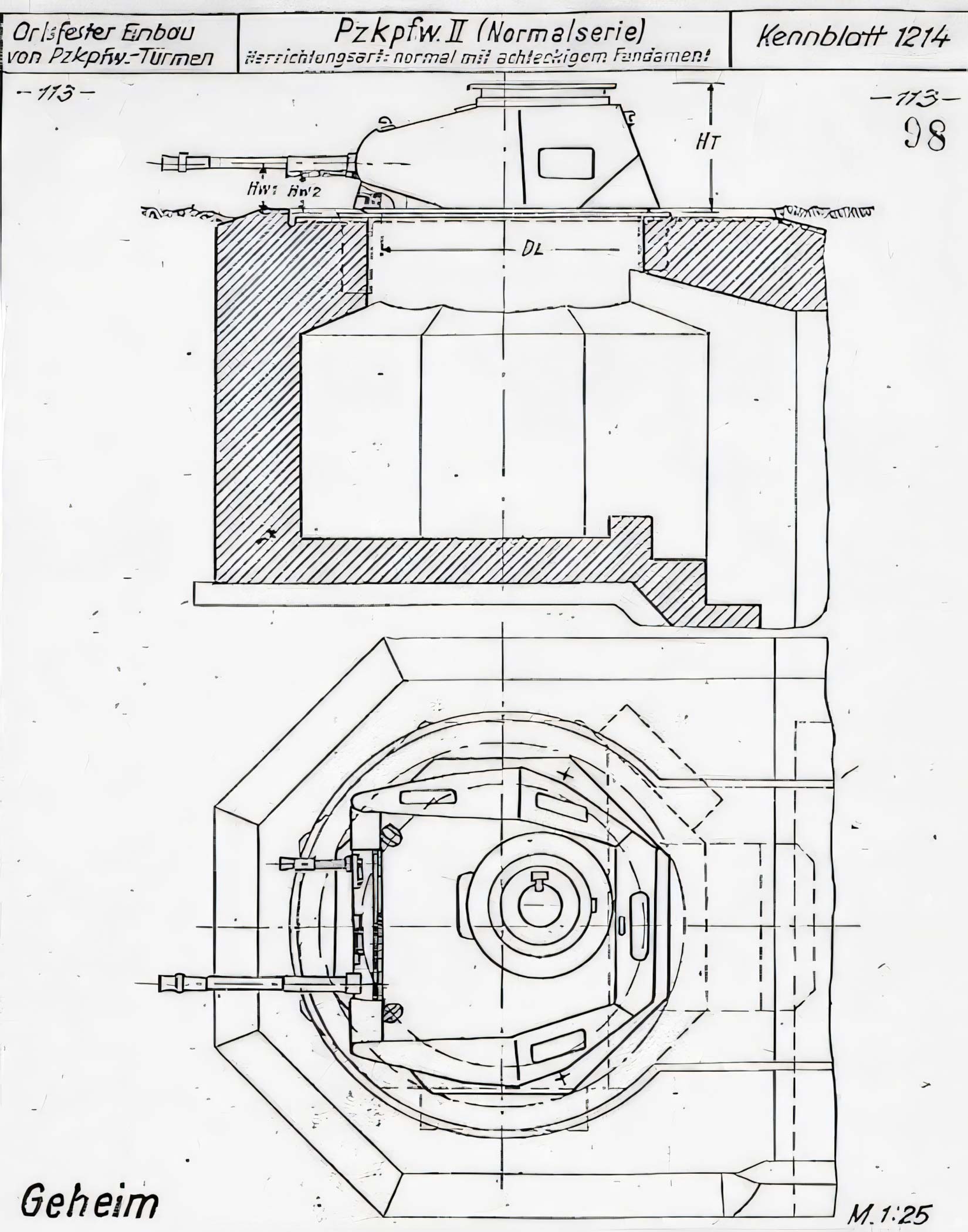
P line Bunker Types
P line bunkers are all different, but these types of bunkers are almost always found. The bunkers were never armed, but they were intended to use the following armaments:Automatic rifle Bunker
 Oviedo Light Machine Gun, 7.92mm caliber
OC Model 1937, 7mm caliber
Machine Gun Bunker
 Several models depending on the region or construction date.
Hotchkiss Model 1914, 7.92mm caliber
Alfa 44, 7.92mm caliber
And possibly the ZB vz. 37, 7.92mm caliber
Firing Steps / Rifle Pits
 Mainly found in Catalonia.
One-man firing pit.
Anti-Tank Gun Bunker
 PaK 40, 75mm caliber
And possibly the Placencia 60/45, 60mm caliber, Placencia 45/44, 45mm caliber..
Anti-Tank Gun Shelter
 Storage garage for guns and ammunition serving an open-air firing platform (barbette).
Incentive Gun Bunker
 Rare.
Rare.75/13 rapid-fire infantry gun
Cannone da 65/17
Anti-Aircraft Machine Gun Bunker
 Oerlikon, 20mm caliber
Mortar Bunker
 Valero 81mm Model 1933
Observatory Bunker
 Observation and command bunker. Size varies by importance, often featuring one or two rooms (e.g., for telephone communications). Some include a fireplace for winter use. Notable observatories:
Observation Pit
 Rare.
Rare.One-man observation pit, often connected to a tunnel.
Refuge Bunker
 Three parallel tunnels, interconnected by a larger tunnel. Most remain unfinished, consisting only of the three main tunnels.
Ammunition Depot
 Rare.
Rare.Features double walls for moisture control and entrances protected by blast walls.
Blockhouses
 Rare.
Rare.Large bunker with 11 to 20 embrasures for rifle and automatic rifle fire. 2 blockhouses also feature a machine gun emplacement. Likely built during the early years.
Trenches
Rare.
Trench network, occasionally made of concrete or stone.
Bunker Complexes
Multiple bunkers of different types linked by tunnels spanning several hundred meters. Some feature pits for hand grenades (grenadier bunker). Likely built during the early years.
The walls and ceilings would be 75 cm thick. Some foundations of unbuilt bunkers have been dug (they are not shown on the map). Drains prevent the bunkers from being flooded.
Sperrlinie Pyranäenfront bunker types
Small tank turret
 Reuse of obsolete tank turrets.
Panzer I (above, modified for MG 34 machine gun)
Panzer II
Panzer 38(t)
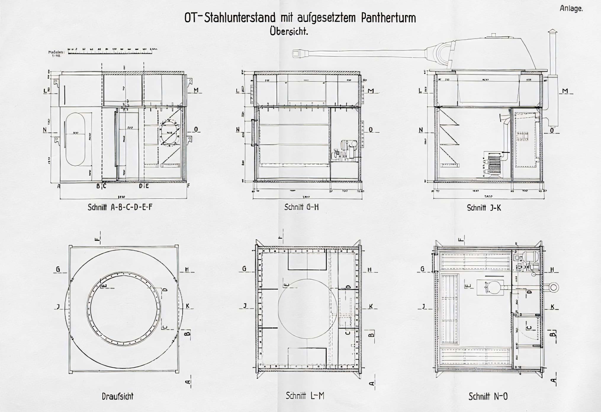
Panzer V Turret (Pantherturm)
 Steel bunker for Panzer V, equipped with an emergency exit, two folding bunks and space for a Wt80k stove. A small engine powered a generator and an air compressor for the turret.


Learn more:
General Instruction No. 4 (in Spanish)
Concrete borders
Excerpt from a documentary (in Spanish)
A documentary (in Catalan)
RTVE documentary
The Franco-style Maginot line (in French)
The Línea P on Wikipedia
Bunquers Park of Martinet i Montellà (in Catalan)
The bunkers of Cerdagne - pdf (in Catalan)
Archeology of the Línea P in the region of Jacetania (in Spanish)
Fortification Vallespin - pdf (in Spanish)
Bunkers of Cape Higer - pdf (in Spanish)
Arma Plaza Fondation (in Spanish)
Article on the Sperrlinie Pyranäenfront (in French)
Civil war bunkers in the Pyrenees (in Catalan)
Book: Els fortins de Franco a la Vall de Ribes - Carles Puncernau - MMV Edicions (in Catalan)
Explore
- A powerful flashlight is essential to enter bunkers.
- Check where you are stepping, falls are always possible, especially in manholes...
- Gardening tools can be used to clear the entrance to the most overgrown bunkers.
- Bunkers may contain litter, dead animals or be flooded.
- Some bunkers are on private property.
- Some bunkers are home to adorable bats that are harmless if you leave them alone (their bite can transmit rabies).
Contact
You want:- Provide us with the GPS coordinates of a bunker
- Make a correction
- Access map modification
- Send us an article about the Línea P
- Improve the translation
Contact me!
Mother tongue: French | Languages understood: Spanish, English
Carte de la Línea P is a voluntary non-profit collaborative project.